
This route is a spectacular “Coast and Coal” loop that showcases the hidden geographical diversity of South Tyneside. Covering approximately 13 to 14 miles (21-22km), it transitions from reclaimed industrial wetlands to limestone hills, rugged cliffside trails, and historic riverside quays.
Location & Setting
Starting at the Tile Sheds Nature Reserve on the border of East Boldon and South Shields, this route sits in the low-lying “Magnesian Limestone” belt of North East England. It’s a journey from the inland agricultural fringe to the dramatic North Sea coast, finishing with a flat, fast sprint along the banks of the River Tyne.
Phase 1: The Ascent to the Hills
Leaving the reed beds of Tile Sheds—once the site of a thriving Victorian brick and tile industry—the trail heads east toward Cleadon Village. This is a gentle, leafy warm-up before the first significant climb.
- Cleadon Hills: As you ascend towards the summit (approx. 60m elevation), the terrain shifts to limestone grassland.
- The Windmill & Water Tower: You’ll pass the iconic Cleadon Windmill, a stone-built structure dating back to the 1820s. Nearby stands the Victorian Water Tower, a Venetian-style campanile that once pumped water from the deep chalk aquifers below.
- The View: From this ridge, you get a 360-degree panorama: the Cheviots to the north, the Pennines to the west, and the blue expanse of the North Sea to the east.
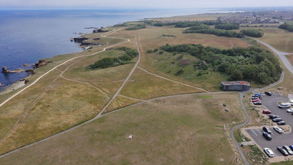
Phase 2: The Quarry and the Coast
The descent from Cleadon Hills takes you across the South Shields Golf Course via a public right of way. Watch for low-flying golf balls as the trail narrows into Old Marsden Quarry Nature Reserve.
- Terrain: This is a technical section. The quarry, once a source of lime for the steel industry, is now a rugged bowl of wildflowers and steep limestone walls.
- Marsden Bay: Emerging from the quarry, you hit the coast at the world-famous Marsden Rock. This 100-foot limestone stack is a sanctuary for kittiwakes and fulmars. The scent of sea salt and the sound of crashing waves provide a sharp contrast to the quiet hills you just left.
Phase 3: The Coastal Gallop (The Leas)
From Marsden, you join the Coastal Path heading north across The Leas. This is 2 miles of wide, springy turf—a runner’s dream.
- Trow Rocks: Look out for the historic disappearing gun, a remnant of the coastal defenses from the late 19th century.
- Sandhaven Beach: Descending to sea level, the terrain shifts to the hard-standing Promenade. This is the flattest, fastest part of the route, flanking the award-winning Sandhaven dunes.
- The South Pier: Reaching the mouth of the Tyne, you run the gauntlet of the South Pier (weather permitting). This massive stone structure marks the entrance to one of the UK’s most historic industrial rivers.
Phase 4: The River & The Customs House
Rounding the “Groyne” lighthouse, the route enters the River Tyne estuary.
- Little Haven: You’ll pass the “Conversation Piece” (the “Beamily” statues) on the beach before heading toward South Shields Town Center.
- The Customs House: This Grade II listed building at Mill Dam is the cultural heart of the riverside. Once the place where merchant ships paid their dues, it now overlooks the Shields Ferry and the shifting tides of the Tyne.
- History: You are running through the footprint of the Roman Fort Arbeia and the former sites of massive shipyards that once built the world’s greatest fleets.
Phase 5: The Home Stretch (The Old Railway Line)
From the industrial landscape of Tyne Dock, the route picks up the disused railway line (part of the National Cycle Network).
- Terrain: This is a dead-straight, sheltered corridor of greenery. It’s a steady, almost imperceptible climb back toward Boldon.
- The Finish: The tree-lined path leads you directly back into the Tile Sheds Nature Reserve, closing the loop where the old clay pits have been reclaimed by nature.


Leave a Reply