
This is the ultimate “Two Rivers Loop”—a formidable endurance route covering approximately 23 miles (37km). It is a run of incredible contrasts, taking you from the quiet wetlands of Boldon, through the heart of Sunderland’s industrial history, along the wild limestone cliffs of the North Sea, and finally tracking the mighty River Tyne back home.
Location & Setting
This route effectively circumnavigates the northeastern corner of the ancient County Durham palatinate (now South Tyneside and Sunderland). It begins at the Tile Sheds Nature Reserve, once a noisy Victorian industrial site where clay was dug for the region’s construction boom. You’ll traverse the “Magnesian Limestone” plateau—a rare geological feature that gives this coastline its unique cliffs and specialized flora.
Phase 1: The Boldon & Wearside Approach
The opening miles are a masterclass in suburban navigation and steady rhythm.
- Boldon to East Boldon: Starting at Tile Sheds, you head toward the Boldon Asda and the Travelling Man pub. This is a flat, paved section, perfect for settling into your target heart rate.
- Fulwell Windmill: As you push through East Boldon and pass the Sunderland Greyhound Stadium, the terrain begins to rise. You’ll pass the Fulwell Windmill, built in 1808. It stands as a sentinel over the city, constructed from the very limestone you’ll be running on later.
- The Wearmouth Bridge: A sweeping descent brings you to the bridge. Crossing the Wear, you have a panoramic view of the city’s shipbuilding past and its future at the St Peter’s Campus.
Phase 2: The River Wear & The Glass Centre
Dropping down from the bridge, you enter a zone of deep history.
- St Peter’s & The Glass Centre: You are running through the grounds of the Monkwearmouth-Jarrow Abbey, home to the Venerable Bede in the 7th century. The path here is flat and ultra-modern, passing the National Glass Centre.
- Roker Marina: You’ll loop around the marina and the Sailing Club, where the air turns sharp with sea salt. The terrain shifts to the hard-standing promenade of Roker Beach.
Phase 3: The Coastal Frontier (Seaburn to Whitburn)
From Roker, you head north through the ornamental Roker Park (a Victorian gem) and back onto the coastal path.
- Seaburn Promenade: This is a long, exposed 2-mile stretch. It’s flat and fast, but often plagued by a northerly headwind that will test your mental resolve.
- Whitburn Village: Reaching Whitburn, the route begins to feel wilder. You leave the promenade and join the Coastal Path, heading toward South Shields.
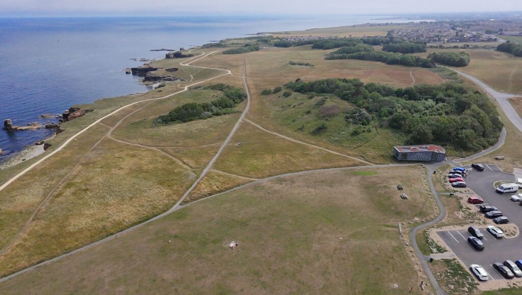
Phase 4: The Wild Cliffs (Souter to The Leas)
This is the “crown jewel” of the run. The tarmac disappears, replaced by springy turf and gravel trails.
- Souter Lighthouse: You’ll pass behind the old army camp (Whitburn Ranges) toward Souter Lighthouse. Opened in 1871, it was the first lighthouse in the world designed to be powered by alternating electric current.
- Marsden Bay & The Leas: The “Winding” path along the clifftops at Marsden is spectacular. To your right are 100-foot drops to the North Sea and the iconic Marsden Rock. You are running on The Leas, a 300-acre marvel of National Trust land.
- Trow Rocks: Look for the “disappearing gun” and the ancient limestone formations as you head toward the soft sands of Sandhaven Beach
Phase 5: The Tyne & The Industrial Heart
Rounding the corner at South Shields, the North Sea gives way to the River Tyne.
- The Groyne & South Pier: You’ll hit the mouth of the river, marked by the distinctive red lighthouse of the Groyne. From here, you track the river upstream.
- Mill Dam: Following the promenade past Little Haven, you reach the Customs House at Mill Dam. This was once the chaotic hub of the Tyne’s merchant navy.
- Port of Tyne & Tyne Dock: The route becomes gritty and industrial as you follow Commercial Road. You are running alongside the Port of Tyne, where massive car-carriers and bulk vessels are docked. The terrain is flat, but the industrial scale is humbling.
Phase 5: The Tyne & The Industrial Heart
The final leg requires one last push of effort.
- The John Reid Road: Heading inland from Tyne Dock, you join the John Reid Road. For fans of the Great North Run, this is “reverse territory.” It’s a long, steady, and often grueling incline that tests your remaining glycogen stores.
- The Finish: From the top of the ridge, you descend back toward the Tile Sheds, closing a massive loop that has seen you cross two major rivers and nearly 2,000 years of British history.


Route Statistics & Technical Terrain
Total Distance: ~32-34km (Approx. 20-21 miles).
Total Ascent: Approx. 180m. While it’s a “coastal” route, the climb from the river up to the John Reid Road and the “kick” at Fulwell Windmill provide the vertical challenge.
Terrain Profile: * 60% Pavement/Promenade: (Boldon, Sunderland, Seaburn, South Shields Riverside).
- 30% Coastal Trail/Grass: (Whitburn to Trow Rocks).
- 10% Industrial Roadside: (Tyne Dock/Commercial Road).
Leave a Reply