
There are routes in the Lake District that earn their reputation through raw altitude and brutal effort. The Ambleside–Rydal Loop is a more nuanced beast. It threads together road, estate trail, ancient moorland path, and riverside woodland to create a circuit that feels far more varied than its modest numbers suggest. It’s a route with history pressed into every surface — Roman, medieval, literary — and the kind of rolling, ever-changing terrain that keeps your attention locked in from first stride to last.
This route is perfect for a relaxing walk with your four-legged companions, an energizing hike or challenging trail run. How ever you experience Rydal, it will stay with you.

Location
This roughly 5-to-6-mile loop (depending on specific path choices) is a masterclass in varied terrain. It transitions seamlessly from bustling Victorian townscapes to ancient woodlands, tranquil lakeside singletrack, and historic parklands. Starting in Ambleside and heading north toward Rydal Hall, the route follows the “eastern” side of the valley before looping back along the “western” flanks of Loughrigg Fell.
Mile 0 to 1: The Gateway t the Valley
The journey begins in Ambleside, a town that has served as the hub of Lake District tourism since the arrival of the railway in nearby Windermere in 1847. As you tighten your laces near the iconic Bridge House—a tiny, two-roomed building perched over Stock Beck that once served as a counting house for the local mills—the air is thick with the scent of woodsmoke and damp slate.
The first mile takes you away from the traffic of the A591 and onto the quiet, paved lane of Under Loughrigg. For a runner, this is the perfect warm-up. The terrain is flat and forgiving, allowing your lungs to adjust to the crisp Cumbrian air. To your left, the River Rothay bubbles along, often swollen with the rains of the high fells. You pass through a corridor of ancient oak and beech trees, their roots intertwining with the stone walls that have stood for centuries.
The flow here is fast and rhythmic. You are leaving the urban “noise” behind and entering the pastoral “quiet” that inspired the Lake Poets. As the mile closes, you approach the entrance to the Rydal estate, and the transition from road to trail begins.
Mile 1 to 2: The Hall, the Poet, and “The Grot”
As you reach the one-mile mark, the silhouette of Rydal Hall appears. Since the 16th century, this has been the seat of the Le Fleming family. The history here is palpable. For the outdoor enthusiast, the highlight is the Quiet Garden. If you have the time to break your stride, a short detour leads to “The Grot”—a tiny stone summerhouse built in 1668. It is widely considered the first purpose-built “viewing station” in the UK, designed specifically to frame the lower Rydal Falls for the “Picturesque” movement of the 17th century.
As you push past the Hall, the terrain kicks up. You are now running on the lower fringes of Rydal Mount, the home of William Wordsworth from 1813 until his death in 1850. The trail becomes a mix of gravel and packed earth. The flow changes; your cadence shortens as you navigate the slight incline. To your right, the views across the valley toward the Fairfield Horseshoe begin to open up. You aren’t just running through nature here; you are running through a landscape that was quite literally curated by the father of English Romanticism.
Mile 2 to 3: The Shoreline and the Echoes of Industry
Crossing the bridge at the foot of Rydal Water, you transition to the southern side of the lake. This is where the “trail” truly begins. The pavement is a distant memory, replaced by a technical, undulating track that hugs the shoreline.
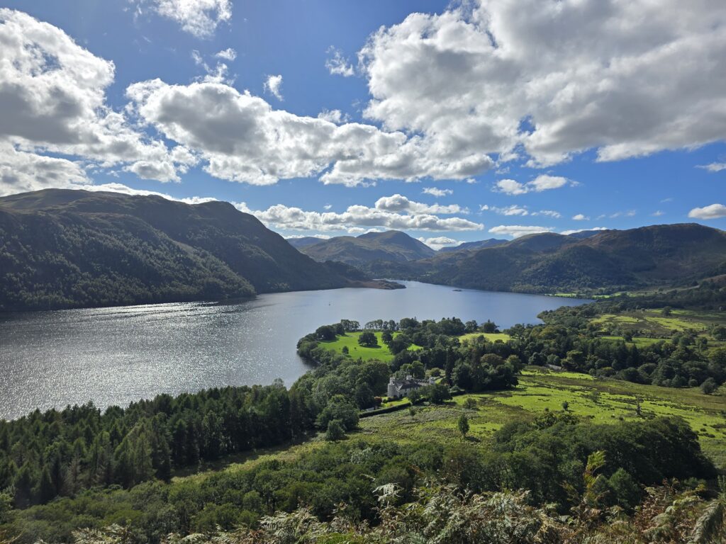
This mile is arguably the most scenic. To your right, the glassy surface of Rydal Water reflects the surrounding fells. In the center of the lake sits Heron Island, where grey herons have nested for generations. The terrain here is a delight for the feet: a tapestry of slate shards, tree roots, and soft pine needles.
The key point of interest here is Rydal Caves. These are not natural caverns but the remnants of a 19th-century slate quarry. As you climb the short, sharp spur to reach the main cavern, the “trail flow” demands a bit of power-hiking. Stepping into the cave is a sensory experience—the temperature drops, the acoustics turn metallic, and the jagged roof reminds you of the grit and toil of the miners who hollowed out this fellside. For the runner, the exit from the cave offers a fast, technical descent back toward the main terrace.
Mile 3 to 4: Loughrigg Terrace and the Classic Vista
Leaving the caves behind, you hit Loughrigg Terrace. For many, this is the definitive highlight of the loop. The path here is a wide, well-maintained balcony trail that contours around the northern shoulder of Loughrigg Fell.
The flow here is magnificent. The path is relatively flat, allowing you to open up your stride and find a high-speed cruise. But the challenge is keeping your eyes on the trail. Below you, the view opens up over Grasmere, with the tiny island in the center and the village nestled at the foot of Helm Crag (The Lion and the Lamb).
This is the landscape of the “Excursion.” You are running through the very heart of the UNESCO World Heritage site. The terrain is firm underfoot, consisting of crushed slate and stone pitching. As you round the corner of the terrace, the wind often picks up, coming off the high fells of the Langdales. It is a moment of pure, unadulterated “fells” experience without having to climb 3,000 feet.
Mile 4 to 5: The Descent and the Stepping Stones
As the loop begins its southern turn, the trail starts to descend back toward the Rothay Valley. The terrain becomes more technical again—steep, rocky steps that require quick footwork and strong quads. This is the part of the run where “trail flow” becomes “downhill focus.”
You are heading toward the Stepping Stones under Loughrigg. These massive, flat-topped rocks provide a traditional crossing of the River Rothay. Depending on the rainfall, the river might be rushing over them, requiring a balance-testing hop or a wet-footed splash through the shallows.
Historically, this area was a favorite of the Victorians, who would take their carriages along the lower roads to watch the “rugged” hikers return from the hills. For the modern runner, it marks the home stretch. You have transitioned from the high, airy terrace back down to the sheltered, lush riverbank.
Mile 5 to Finish: The Parkland Sprint
The final mile is a victory lap through Rothay Park. After the technical rocks and the steep descents, the soft, manicured grass of the park is a welcome relief. The flow is easy and relaxed. You pass the parish church of St. Mary’s, where the bells often ring out across the valley, and find yourself back in the heart of Ambleside.
As you finish near the climbing walls and the outdoor shops, the loop is complete. You have traveled through 1,500 years of history—from the Roman fort of Galava (just a mile to the south) to the Victorian villas and the modern trail-running culture that now defines the town.
The Experience: A Summary
The Ambleside–Rydal loop is more than just a training run; it is a distilled version of the Lake District. In less than 6 miles, you experience the dramatic shift from the industrial (the caves) to the literary (Wordsworth) and the pastoral (the river meadows).
For the Runner: The route demands versatility. You need the “engine” for the climb to the caves, the “brakes” for the descent from the terrace, and the “cadence” for the flat river paths. For the Enthusiast: It is a walk through a living gallery. Every turn of the trail offers a view that has been painted, photographed, and written about for three centuries.
Whether you are chasing a personal best on the “Under Loughrigg” segment or simply looking for a soul-soothing walk before a pub lunch in Ambleside, this loop remains a timeless classic. It proves that you don’t need to stand on the highest peak to feel the full weight and beauty of the Lakeland fells.


Leave a Reply